Highway 89: Highway 395 Junction to Highway 88: March 2008 Archives
Road condition: Paved
Region: Alpine
County / Markleeville Tributaries: Silver Creek and
Description:
Species: Stocked rainbows
Closest town or supplies: Markleeville
Contacts:
Nearest campground: Silver Creek Campground, Markleeville Campground, Grover Hot Springs State Park, Turtle Rock County Campground, Indian Creek Reservoir Campground
Fishing season: General season
Tips:
Favorite lures or
bait:
Favorite fly
patterns:
Stocking information: 20,000+ trout in the 10-12-inch range
Nearby fishing: Indian Creek Reservoir, West Fork Carson River
Additional
information:
Directions: From Highway 395, turn left at the junction
with Highway 89 and proceed over
Markleeville: For tourism information contact: The
Alpine County Visitor’s Bureau,
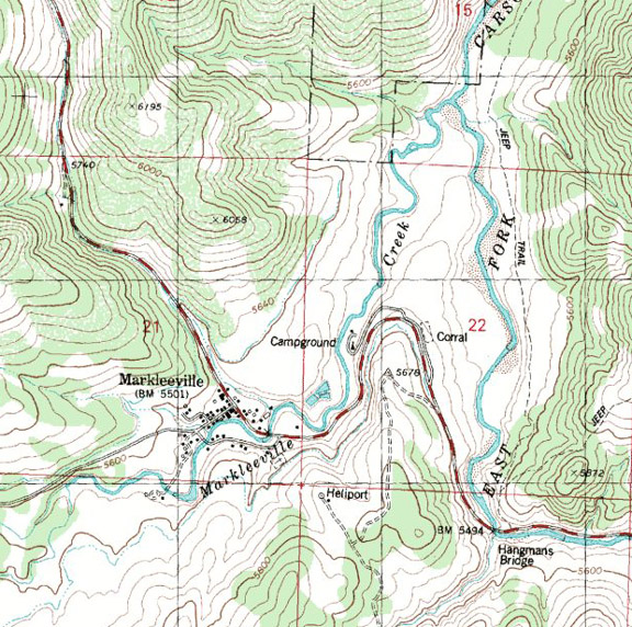
Markleeville Campground / Highway 89
Area: South
of
Administered by: Carson Ranger District (775) 882-2766
Elevation: 5,500
Season Length: Subject to weather conditions, April - September
Number of sites: 10
Fee: $14. Extra vehicle: $5 Day Use: $5.
RV sites: Yes RV’s up to: Hook-ups: Garbage: containers Pack-it-out!
Toilets: Vault Water: Yes Picnic tables and fire grills
Bear-proof food storage lockers
Nearest town: Markleeville
Nearby facilities: Markleeville
Nearby fishing: The campground is located on Markleeville Creek, which holds small
trout. The East and West Forks of the
Carson River, Silver Creek and
Reservations: No
Additional information:
The access road to the
campground is paved, although the campground road is not. Pets must be kept on a leash. Please note that the dates and prices above
are subject to change and reflect 2008 data.
If listed, the campground opening dates are approximate due to weather
conditions.
Directions: From
Highway 395, turn north on Highway 89.
Proceed to the town of
Area: 30
miles south of
Elevation: 6,000
Administered by: California State Parks (www.parks.ca.gov/) General information: (530) 694-2248; Pool information: (530) 694-2249
Features: The
state park has a pool complex with a hot pool and a swimming pool fed by
Season: Open-year-round. The facilities are closed during severe storms, and seasonal hours and days of operation change during the off-season months so it is best to call in advance. During the winter months, the pool is closed on Wednesdays. The pool facilities are closed for two weeks in September for cleaning and maintenance.
Number of camping sites: 76, two of which are designed for wheelchair use and accessible restrooms
are nearby. The campgrounds are closed
from early October to May. Camping is
permitted in the day-use area adjacent to the park entrance during the winter
for a $20 fee. (No showers)
Fee: $20-25,
$6. for additional vehicle. Pool fees
are $5 for adults and $2 for children
Tent sites: 26 RV sites:
50 RV’s up to: 27-feet and trailers up to 24-feet No Hook-ups
Garbage: containers
Bear-proof food storage lockers
Toilets: Flush Water: Yes Picnic tables and fire grills
Showers: Coin operated – summer only
Nearest town: Markleeville
Facilities: A
small grocery store is four miles away.
Nearby fishing: East and West Forks of the
Reservations: Yes. (Reservation
fee)
Additional information: Pets must be kept on a leash. Please note that the dates and prices above are subject to change and reflect 2008 data. For a reservable campsite, phone toll free at 877-444-7275. For on-line reservations: www.reserveamerica.com.
Directions: From
Markleeville take the
Area: Markleeville
area
Administered by: Alpine County Public Works Department, (530) 694-2140
Elevation: 5,900
Setting: The
park offers a wooded setting.
Season Length: Subject to weather conditions, May-September
Number of sites: 28
Fee: $10 and
$3. for additional vehicle
RV sites: Yes RV’s up to: 34-feet No Hook-ups: Garbage: containers
Toilets: Vault Water: Yes Showers: Yes Picnic tables and fire grills
Nearest town: Markleeville
Nearby facilities: Markleeville
Nearby fishing: East and West Fork of the
Reservations: No
Additional information: A camp host is on site. Pets must be kept on a leash. Please note that the dates and prices below are subject to change and reflect 2007 data. If listed, the campground opening dates are approximate due to weather conditions.
Directions: From
Highway 395, turn left on Highway 89 and drive _____miles to Markleeville. Continue another _____ miles to the
campground entrance on the left side of the road.
Indian Creek Reservoir / Highway 89
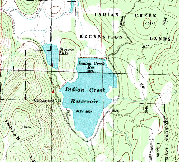
Elevation: 5,600
Road condition: Paved
Region: Highway
89 north of Markleeville
Description: Indian
Creek Recreation Reservoir is a popular destination for
Closest town or supplies: Markleeville
Contacts:
Facilities: Lodge, marina, grocery store, bait and tackle, coin-laundry, coin-showers, RV campground
Nearest campground:
Boating:
Fishing season: General season
Tips:
Favorite lures or bait: Trolling is by far the most popular fishing method. The reservoir is not known for good fishing throughout the season.
Favorite fly
patterns:
Stocking information: 15,000 fingerling rainbows yearly
Additional
information:
Nearby fishing:
Directions: : From Highway 395, turn left on Highway 89 and
drive _____miles to Markleeville.
Continue another four miles to
Indian Creek BLM Campground / Highway 89
Map courtesy of mytopo.com
Area: Markleeville
area
Bureau of Land Management
Administered by: Carson City Field Office, (775) 885-6000
Elevation: 5,600
Setting: Surrounded
by ponderosa and Jeffrey pines on the west
Season Length: Subject to weather conditions, late April to early October
Number of sites: 19 (10 walk-in sites for tents only and one group tent site, which
requires a reservation.)
Fee: $20 and
double sites are $32. Walk-in sites
range from $14 to $20. Add $5 for each
additional vehicle.
RV sites: Yes RV’s up to: 30-feet No Hook-ups: Garbage: containers
Toilets: Flush Water: Yes Showers: Yes Picnic tables and fire grills
Boat Launch: The maximum speed limit on the lake is 5 mph.
Nearest town: Markleeville
Nearby facilities: Markleeville
Nearby fishing: The 160 acre lake offers fair trout fishing. Nearby is the
Reservations: No
Additional information: Pets must be kept on a leash. Please note that the dates and prices above are subject to change and reflect 2007 data. If listed, the campground opening dates are approximate due to weather conditions. Dead and down wood may be gathered from BLM lands for campfires.
Directions: From
Highway 395, turn left on Highway 89 and drive _____miles to Markleeville. Continue another four miles to
