Mammoth Camping: January 2008 Archives
Campground Name: Agnew Meadows Horse Campground
Area:
Administered by:
Elevation: 8,400
Season Length: 6/8-9/16 subject to weather conditions
Contact: Mammoth Ranger District and
http://www.visitmammoth.com/
Number of sites: 3
Fee: $19.
RV sites: Yes RV’s up to: Hook-ups: Garbage: containers Pack-it-out!
Toilets: Vault Water: Yes Picnic tables and fire grills
Nearest town:
Nearby facilities:
Nearby fishing: Middle
Fork of the
Reservations: For
reservable campsites, contact the
Additional
information: Pets must be kept on a
leash. Please note that the dates and
prices below are subject to change and reflect 2008 data. If listed, the campground opening dates are
approximate and subject to weather conditions. Located in the eastern Sierra
west of
Directions: From
Highway 395 and the junction with Highway 203, drive west through
Note: If you are visiting the Red’s Meadow area via the shuttle bus, here are the scheduled stops:
Agnew Meadows - trailheads for Shadow, Ediza, Thousand Island & Garnet lakes; Pacific Crest & John Muir trails; pack station; & camping;
Upper Soda Springs Campground – ½-mile walk to camping & river fishing;
Pumice Flat Campground turnoff - camping; group camping by reservation only; Ranger's cabin; pay phone; & amphitheater
Devils Postpile National Monument - camping; picnicking; Ranger Station; pay phone; information; books & maps; tours & programs; trailheads for Minaret & Beck lakes, Summit Meadow & John Muir Trail. 1/4-mile walk to the postpile rock formation
Reds Meadow Campground - camping; bath house; trailheads for Mammoth Pass & Pumice Flat
Reds Meadow Resort - pack station; store, cafe, cabins, pay phone.
Campground Name: Agnew Meadows Campground
Area:
Administered by:
Elevation: 8,400
Season Length: 6/8-9/16 subject to weather conditions
Contact: Mammoth Ranger District and
http://www.visitmammoth.com/
Number of sites: 21
Fee: $16.
RV sites: Yes RV’s up to: 45 feet No Hook-ups: Garbage: containers
Toilets: Vault Water: Yes Picnic tables and fire grills
Nearest town:
Nearby facilities:
Nearby fishing: Middle
Fork of the
Reservations: No
Additional
information: Pets must be kept on a
leash. Please note that the dates and
prices below are subject to change and reflect 2008 data. If listed, the campground opening dates are
approximate and subject to weather conditions.
The campground is located 1/2 hour from
Directions: From Highway 395 and the junction with
Highway 203, drive west through
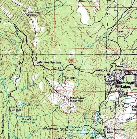
Map courtesy of mytopo.com.Note: If you are visiting the Red’s Meadow area via the shuttle bus, here are the scheduled stops:
Agnew Meadows - trailheads for Shadow, Ediza, Thousand Island & Garnet lakes; Pacific Crest & John Muir trails; pack station; & camping;
Upper Soda Springs Campground – ½-mile walk to camping & river fishing;
Pumice Flat Campground turnoff - camping; group camping by reservation only; Ranger's cabin; pay phone; & amphitheater
Devils Postpile National Monument - camping; picnicking; Ranger Station; pay phone; information; books & maps; tours & programs; trailheads for Minaret & Beck lakes, Summit Meadow & John Muir Trail. 1/4-mile walk to the postpile rock formation
Reds Meadow Campground - camping; bath house; trailheads for Mammoth Pass & Pumice Flat
Reds Meadow Resort - pack station; store, cafe, cabins, pay phone.
Campground Name:
Area:
Administered by:
Elevation: 7,600
Season Length: Mid June opening, subject to weather conditions—see other campground opening dates
Contact: Information (760) 934-2289 http://www.nps.gov/archive/depo/depomain.htm;
Mammoth Ranger District and
http://www.visitmammoth.com/
Number of sites: 21
Fee: $14.
RV sites: Yes RV’s up to: 25 feet No Hook-ups: Garbage: containers
Toilets: Flush Water: Yes Picnic tables and fire grills
Nearest town:
Nearby facilities:
Nearby fishing: Middle
Fork of the
Reservations: For
reservable campsites, contact the
Additional
information: Pets must be kept on a
leash. Please note that the dates and
prices below are subject to change and reflect 2008 data. If listed, the campground opening dates are
approximate and subject to weather conditions. All visitors to the
Directions: From
Highway 395 and the junction with Highway 203, turn left and drive 4 miles
through the town of
Note: If you are visiting the Red’s Meadow area via the shuttle bus, here are the scheduled stops:
Agnew Meadows - trailheads for Shadow, Ediza, Thousand Island & Garnet lakes; Pacific Crest & John Muir trails; pack station; & camping;
Upper Soda Springs Campground – ½-mile walk to camping & river fishing;
Pumice Flat Campground turnoff - camping; group camping by reservation only; Ranger's cabin; pay phone; & amphitheater
Devils Postpile National Monument - camping; picnicking; Ranger Station; pay phone; information; books & maps; tours & programs; trailheads for Minaret & Beck lakes, Summit Meadow & John Muir Trail. 1/4-mile walk to the postpile rock formation
Reds Meadow Campground - camping; bath house; trailheads for Mammoth Pass & Pumice Flat
Reds Meadow Resort - pack station; store, cafe, cabins, pay phone.
Campground Name: Upper Soda Springs Campground
Area:
Administered by:
Elevation: 7,
Season Length: 6/8-9/4 subject to weather conditions
Contact: Mammoth Ranger District and
http://www.visitmammoth.com/
Number of sites: 28
Fee: $16.
RV sites: Yes RV’s up to: 36 feet No Hook-ups: Garbage: containers
Toilets: Vault Water: Yes Picnic tables and fire grills
Nearest town:
Nearby facilities:
Nearby fishing: Middle
Fork of the
Reservations: No
Additional
information: Pets must be kept on a
leash. Please note that the dates and prices
below are subject to change and reflect 2008 data. If listed, the campground opening dates are
approximate and subject to weather conditions. All visitors to the
Directions: From
Highway 395 and the junction with Highway 203, turn left and drive 4 miles
through the town of
Note: If you are visiting the Red’s Meadow area via the shuttle bus, here are the scheduled stops:
Agnew Meadows - trailheads for Shadow, Ediza, Thousand Island & Garnet lakes; Pacific Crest & John Muir trails; pack station; & camping;
Upper Soda Springs Campground – ½-mile walk to camping & river fishing;
Pumice Flat Campground turnoff - camping; group camping by reservation only; Ranger's cabin; pay phone; & amphitheater
Devils Postpile National Monument - camping; picnicking; Ranger Station; pay phone; information; books & maps; tours & programs; trailheads for Minaret & Beck lakes, Summit Meadow & John Muir Trail. 1/4-mile walk to the postpile rock formation
Reds Meadow Campground - camping; bath house; trailheads for Mammoth Pass & Pumice Flat
Reds Meadow Resort - pack station; store, cafe, cabins, pay phone.
Campground Name:
Area:
Administered by:
Elevation: 7,600
Season Length: 6/8-9/23 subject to weather conditions
Contact: Mammoth Ranger District and
http://www.visitmammoth.com/
Number of sites: 27
Fee: $16.
RV sites: Yes RV’s up to: 47 feet No Hook-ups: Garbage: containers
Toilets: Vault Water: Yes Picnic tables and fire grills
Nearest town:
Nearby facilities:
Nearby fishing: Middle
Fork of the
Reservations: No
Additional
information: Pets must be kept on a
leash. Please note that the dates and
prices below are subject to change and reflect 2008 data. If listed, the campground opening dates are
approximate and subject to weather conditions. All visitors to the
Directions: From
Highway 395 and the junction with Highway 203, turn left and drive 4 miles
through the town of
Note: If you are visiting the Red’s Meadow area via the shuttle bus, here are the scheduled stops:
Agnew Meadows - trailheads for Shadow, Ediza, Thousand Island & Garnet lakes; Pacific Crest & John Muir trails; pack station; & camping;
Upper Soda Springs Campground – ½-mile walk to camping & river fishing;
Pumice Flat Campground turnoff - camping; group camping by reservation only; Ranger's cabin; pay phone; & amphitheater
Devils Postpile National Monument - camping; picnicking; Ranger Station; pay phone; information; books & maps; tours & programs; trailheads for Minaret & Beck lakes, Summit Meadow & John Muir Trail. 1/4-mile walk to the postpile rock formation
Reds Meadow Campground - camping; bath house; trailheads for Mammoth Pass & Pumice Flat
Reds Meadow Resort - pack station; store, cafe, cabins, pay phone.
Campground Name: Red’s Meadow Campground
Area:
Administered by:
Elevation: 7,700
Season Length: 6/8-9/23 subject to weather conditions
Contact: Mammoth Ranger District and
http://www.visitmammoth.com/
Number of sites: 52
Fee: $16.
RV sites: Yes RV’s up to: 30 feet No Hook-ups: Garbage: containers
Toilets: Flush Water: Yes Picnic tables and fire grills
Nearest town:
Nearby facilities: Resort; restaurant;
Nearby fishing: Middle
Fork of the
Reservations: No
Additional
information: Pets must be kept on a
leash. Please note that the dates and
prices below are subject to change and reflect 2008 data. If listed, the campground opening dates are
approximate and subject to weather conditions. All visitors to the
Directions: From
Highway 395 and the junction with Highway 203, turn left and drive 4 miles
through the town of
Note: If you are visiting the Red’s Meadow area via the shuttle bus, here are the scheduled stops:
Agnew Meadows - trailheads for Shadow, Ediza, Thousand Island & Garnet lakes; Pacific Crest & John Muir trails; pack station; & camping;
Upper Soda Springs Campground – ½-mile walk to camping & river fishing;
Pumice Flat Campground turnoff - camping; group camping by reservation only; Ranger's cabin; pay phone; & amphitheater
Devils Postpile National Monument - camping; picnicking; Ranger Station; pay phone; information; books & maps; tours & programs; trailheads for Minaret & Beck lakes, Summit Meadow & John Muir Trail. 1/4-mile walk to the postpile rock formation
Reds Meadow Campground - camping; bath house; trailheads for Mammoth Pass & Pumice Flat
Reds Meadow Resort - pack station; store, cafe, cabins, pay phone.
Campground Name: Pumice Flat Campground
Area:
Administered by:
Elevation: 7,700
Season Length: 6/8-9/2 subject to weather conditions
Contact: Mammoth Ranger District and
http://www.visitmammoth.com/
Number of sites: 17
Fee: $16
RV sites: Yes RV’s up to: 45 feet No Hook-ups: Garbage: containers
Toilets: Vault Water: Yes Picnic tables and fire grills
Nearest town:
Nearby facilities: Horse
back riding; small store;
Nearby fishing: Middle
Fork of the
Reservations: For
reservable campsites, contact the
Additional
information: Pets must be kept on a
leash. Please note that the dates and
prices below are subject to change and reflect 2008 data. If listed, the campground opening dates are
approximate and subject to weather conditions. All visitors to the
Directions: From
Highway 395 and the junction with Highway 203, turn left and drive 4 miles
through the town of
Note: If you are visiting the Red’s Meadow area via the shuttle bus, here are the scheduled stops:
Agnew Meadows - trailheads for Shadow, Ediza, Thousand Island & Garnet lakes; Pacific Crest & John Muir trails; pack station; & camping;
Upper Soda Springs Campground – ½-mile walk to camping & river fishing;
Pumice Flat Campground turnoff - camping; group camping by reservation only; Ranger's cabin; pay phone; & amphitheater
Devils Postpile National Monument - camping; picnicking; Ranger Station; pay phone; information; books & maps; tours & programs; trailheads for Minaret & Beck lakes, Summit Meadow & John Muir Trail. 1/4-mile walk to the postpile rock formation
Reds Meadow Campground - camping; bath house; trailheads for Mammoth Pass & Pumice Flat
Reds Meadow Resort - pack station; store, cafe, cabins, pay phone.
Campground Name:
Administered by:
Elevation: 8,600
Season Length: Sites 1-11 5/25-10/28; Sites 16-70 5/15-9/30; Sites 71-95 5/25-10/14, subject to weather conditions
Contact: Mammoth Ranger District and
http://www.visitmammoth.com/
Number of sites: 92
Fee: $19.
RV sites: Yes RV’s up to: 40 feet No Hook-ups: Garbage: containers Pack-it-out!
Toilets: Flush Water: Yes Picnic tables and fire grills
Nearest town:
Nearby facilities: Boat launch (power boats, swimming and other water sports are prohibited. Grocery store; coin-laundry.
Nearby fishing:
Reservations: Yes For reservable campsites, contact the
Additional information: Some wheelchair accessible facilities are
available. Pets must be kept on a
leash. Please note that the dates and
prices below are subject to change and reflect 2008 data. If listed, the campground opening dates are
approximate and subject to weather conditions. Located in the Eastern Sierras
of California near the town of
Directions: From Highway 395 and the junction with Highway
203, turn left and drive 4 miles through the town of
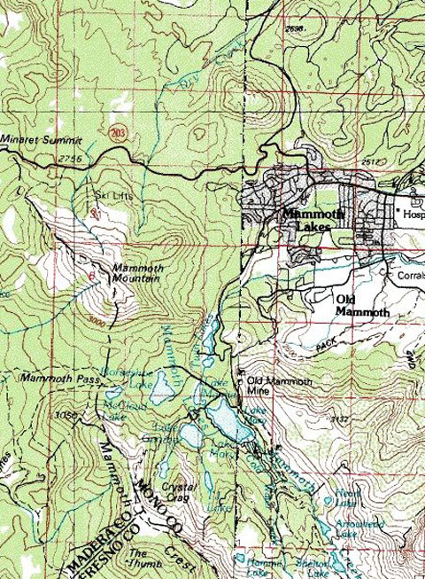
Map courtesy of mytopo.com.
Campground Name: Cold Water Campground (near
Area:
Administered by:
Elevation: 8,900
Season Length: 6/8-9/16 subject to weather conditions
Contact: Mammoth Ranger District and
http://www.visitmammoth.com/
Number of sites: 77
Fee: $19.
RV sites: Yes RV’s up to: 50 feet No Hook-ups: Garbage: containers
Toilets: Flush Water: Yes Picnic tables and fire grills
Nearest town:
Nearby facilities: Boat launch; boat rentals;
Nearby fishing: Day
hike trips to
Reservations: Yes For reservable campsites, contact the
Additional
information: Pets must be kept on a
leash. Please note that the dates and
prices below are subject to change and reflect 2008 data. If listed, the campground opening dates are
approximate and subject to weather conditions. Located in the eastern high
Sierras of California near the town of
Directions: From
Highway 395, turn left on State Highway 203 to
Map courtesy of mytopo.com.
Campground Name:
Area:
Administered by:
Elevation: 8,900
Season Length: 6/8-9/9 subject to weather conditions
Contact: Mammoth Ranger District and
http://www.visitmammoth.com/
Number of sites: 10
Fee: $19.
RV sites: Yes RV’s up to: 40 Hook-ups: Garbage: containers
Toilets: Flush Water: Yes Picnic tables and fire grills
Nearest town:
Nearby facilities: Resort;
boat launch (10 mph restriction); restaurant; coin-laundry
Nearby fishing:
Reservations: No
Additional information: Pets must be kept on a leash. Please note that the dates and prices below are subject to change and reflect 2008 data. If listed, the campground opening dates are approximate and subject to weather conditions.
Directions: From
Highway 395, turn left on State Highway
203 to
Map courtesy of mytopo.com.
Campground Name:
Administered by:
Elevation: 8,900
Season Length: 6/8-9/9 subject to weather conditions
Contact: Mammoth Ranger District and
http://www.visitmammoth.com/
Number of sites: 46
Fee: $19.
RV sites: Yes RV’s up to: 30 feet No Hook-ups: Garbage: containers
Toilets: Flush Water: Yes Picnic tables, fire grills, food lockers
Nearest town:
Nearby facilities: Resort; boat launch (10 mph restriction); restaurant; coin-laundry
Nearby fishing:
Reservations: No
Additional information: No swimming or body contact with the water. Pets must be kept on a leash. Please note that the dates and prices below are subject to change and reflect 2008 data. If listed, the campground opening dates are approximate and subject to weather conditions.
Directions: From
Highway 395, turn left on State Highway
203 to
Map courtesy of mytopo.com.
Campground Name: Lake George Campground Area:
Administered by:
Elevation: 9,000
Season Length: 6/8-9/9 subject to weather conditions
Contact: Mammoth Ranger District and
http://www.visitmammoth.com/
Number of sites: 16
Fee: $19
RV sites: Yes RV’s up to: Hook-ups: Garbage: containers Pack-it-out!
Toilets: Flush Water: Yes Picnic tables and fire grills
Nearest town:
Nearby facilities: Boat launch (small motors only)
Nearby fishing:
Reservations: No
Additional information: Pets must be kept on a leash. Please note that the dates and prices below are subject to change and reflect 2008 data. If listed, the campground opening dates are approximate and subject to weather conditions.
Directions: From
Highway 395, turn left on State Highway
203 to
Map courtesy of mytopo.com.
Campground Name: Sherwin Creek Campground
Area:
Administered by:
Elevation: 7,600
Season Length: 4/25-9/9 subject to weather conditions
Contact: Mammoth Ranger District and
http://www.visitmammoth.com/
Number of sites: 85 (15 walk-in tent sites)
Fee: $18.
RV sites: Yes RV’s up to: 34 feet Hook-ups: Garbage: containers
Toilets: Flush Water: Yes Picnic tables and fire grills
Nearest town:
Nearby facilities:
Nearby fishing: Mammoth lakes and creek
Reservations: For
reservable campsites 52 of 85, contact the
Additional
information: Pets must be kept on a
leash. Please note that the dates and
prices below are subject to change and reflect 2008 data. If listed, the campground opening dates are
approximate and subject to weather conditions.
Sherwin Creek Campground is located in the Eastern Sierras, near the
town of
Directions: Take
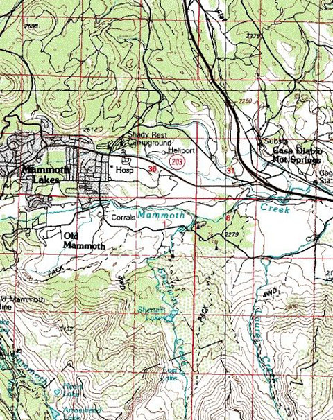
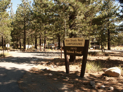
Campground Name: New Shady Rest Campground
Area:
Administered by:
Elevation: 7,800
Season Length: Sites 68-118 4/25-10/28; sites 123-165 5/25-9/16, subject to weather conditions
Contact: Mammoth Ranger District and
http://www.visitmammoth.com/
Number of sites: 95
Fee: $15.
RV sites: Yes RV’s up to: 38 feet Hook-ups: Garbage: containers
Toilets: Flush Water: Yes Picnic tables and fire grills Dump Station
Nearest town:
Nearby facilities: Playground,
grocery store, coin-laundry,
Nearby fishing: Mammoth lakes and creeks
Reservations: For
reservable campsites 50 of 92, contact the
Additional
information: Pets must be kept on a
leash. Please note that the dates and
prices below are subject to change and reflect 2008 data. If listed, the campground opening dates are
approximate and subject to weather conditions.
New Shady Rest Campground is located in the Eastern Sierras next to the
town of
Directions: Take
Map courtesy of mytopo.com.
Campground Name: McGee Creek Campground Area:
Administered by:
Elevation: 7, 600
Season Length: 5/15-10/15 subject to weather conditions
Contact: Mammoth Ranger District and
http://www.visitmammoth.com/
Number of sites: 28
Fee: $17.
RV sites: Yes RV’s up to: 28 feet No Hook-ups: Garbage: containers
Toilets: Flush Water: Yes Picnic tables and fire grills Little Shade
Nearest town:
Nearby facilities:
Nearby fishing: McGee
Creek, Convict Creek,
Reservations: For
reservable campsites, contact the
Additional
information: Pets must be kept on a
leash. Please note that the dates and
prices below are subject to change and reflect 2008 data. If listed, the campground opening dates are
approximate and subject to weather conditions. McGee Creek is located approximately 36 miles northwest of the
town of
Directions: Off US Highway 395 take the first exit after
Crowley Lake, the McGee Creek exit, and proceed 2 miles south up the paved
McGee Creek Road to the campground.
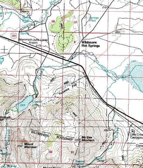
Map courtesy of mytopo.com.
Campground Name:
Administered by:
Elevation: 7,800
Season Length: 4/20-10/31 subject to weather conditions
Contact: Mammoth Ranger District and
http://www.visitmammoth.com/
Number of sites: 85
Fee: $18
RV sites: Yes RV’s up to: Hook-ups: Garbage: containers Pack-it-out!
Toilets: Flush Water: Yes Picnic tables and fire grills Dump Station
Nearest town:
Nearby facilities: Resort, boat launch, store, restaurant, horse back riding
Nearby fishing: Convict
Creek,
Reservations: For
reservable campsites, contact the
Additional
information: Pets must be kept on a
leash. Please note that the dates and
prices below are subject to change and reflect 2008 data. If listed, the campground opening dates are
approximate and subject to weather conditions.
Directions:
Map courtesy of mytopo.com.
Campground Name:
Administered by:
Elevation: 6,800
Season Length: Generally opens the last Saturday in May through November 1; subject to weather conditions
Contact: Mammoth Ranger District and
http://www.visitmammoth.com/
Number of sites: 47
Fee: $5
RV sites: Yes RV’s up to: No size restriction No Hook-ups: Garbage: containers
Toilets: Pit Water: No Potable Water Picnic tables and campfire pits
Nearest town: Mammoth
Nearby facilities: Crowley Lake,
Nearby fishing:
Reservations: No
Additional
information: Pets must be kept on a
leash. Please note that the dates and
prices above are subject to change and reflect 2008 data. If listed, the campground opening dates are
approximate and subject to weather conditions. Horses are prohibited.
Directions: From
Highway 395 approximately 30 miles north of Bishop, turn west on
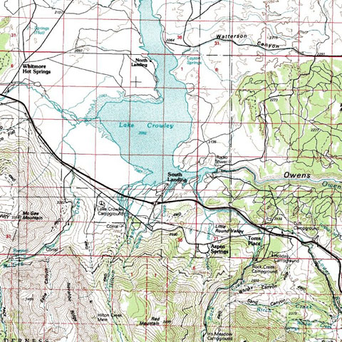
Map courtesy of mytopo.com.
