Highway 395, 209 miles north of Los Angeles and 15.8 miles
south of Independence
Photo Gallery
Restaurants and Eateries: Bonanza Mexican
Restaurant; High Sierra Café, Merry-Go-Round; Mt. Whitney Rest; Pizza Factory;
Season’s Restaurant; Totem Cafe
Public Internet Use Facilities:
Museums and Point of Interest: InterAgency Visitor Center; Manzanar Internment Camp
Events and Festivities:
March 1: Early Opener Trout Derby (Chamber); April 26: Annual
Manzanar Pilgrimage (A delegation of Japanese-Americans and others return to
Mananar to pay tribute to the internees and Japanese-American Veterans who
fought in WW II. Organized by Mansanar
National Historic Site.) May 3: Wild West Marathon (Chamber); October: Lone Pine Film Festival (Chamber); November 15: General Trout
Season Closes
Summer Recreation: Biking, Birding, Camping,
Fishing, Golfing, Hang Gliding, Hiking, Horseback Riding, Mountaineering,
Photography, Rock Climbing.
Sporting Goods Stores: Gardner’s True Value (706)
876-4208; Lone Pine Sporting Goods (760) 876-5365
Nearby Fishing: Home: Lone Pine: Lone Pine Fishing Fishing Tips
Nearby Camping: Home: Lone Pine: Lone Pine Camping
Chamber of Commerce and Visitor Links: www.lonepinechamber.org;
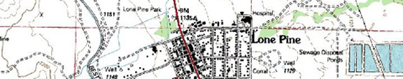
InterAgency Visitor Center at the junction of Highway 395 and Highway 136,
(760) 876-4444. Open 8 am to 4:50
pm. Closed Tuesday and Wednesday in the
off season.
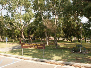
Community Parks:
Tours and Side-Trips: Alabama Hills; Cerro Gordo; Diaz Lake; Horseshoe Meadows; Manzanar Concentration Camp
Weather
RV Related:
Recreational Contacts: Mt. Whitney Golf Club (760)
876-5795; Lone Pine Pheasant Club
Government Contacts:
Inyo
National Forest: books, maps and wilderness passes and permits: Mt. Whitney
Ranger Station (760) 873-2500; White Mountain Ranger Station (760) 873-2500;
Mammoth Ranger Station (760) 924-5500
www.fs.fed.us/r5/inyo
Department
of Fish and Game: (www.dfg.ca.gov/fishing) Season dates, licenses, restrictions,
fish stocking
To provide a correction or offer a suggestion, email David Archer.
Lone Pine Expansion Notes in Alphabetical Order
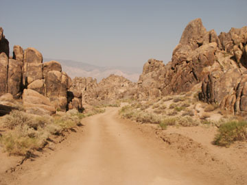
Alabama Hills:
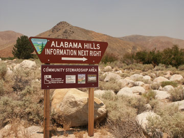
If you are a rock climber, a kid who loves climbing up
boulders or a western movie fan, be sure to visit the Alabama Hills Recreation
Area, a few miles west of Lone Pine.
Into this arid, enchanting rock forest, film directors have been
directing scenes of fabulous rock formations since the 1920’s. Offering majestic vistas of Mount
Whitney and the Sierra escarpment, Alabama Hills is especially
beautiful during the spring when wildflowers dot the sandstone and granite
landscape. Each year Lone Pine celebrates its movie connection with the Lone Pine Film Festival, which for 2008 will be held October 10-12. If you plan on visiting Alabama Hills, be sure to visit the Film Festival web site for their movie road tour.
_____________________________________________________________________________________________
Diaz Lake: Three
miles south of Lone Pine.
Lake size: 22 acres Species: Planted Rainbows
early in the season; Largemouth bass, bluegill, crappie and Channel catfish
Closest town or
supplies: Lone Pine
Contacts: Inyo
County Parks Department; Mt. Whitney Ranger District (760) 876-6200; Lone Pine
Chamber of Commerce: toll-free at (877) 253-8981 or locally at (760) 876-4444;
Lone Pine Sporting Goods (760) 876-5365; Gardner’s
True Value (706) 876-4208
Facilities: Boat
launch; rest rooms, picnic site, swimming area and playground
Nearest campground: Diaz Lake,
Lone Pine Creek, Boulder Creek RV (760) 876-4243
Boating: Personal
watercraft allowed
Fishing season: Early
opener-see regulations Best times: Spring and late fall
Favorite lures or
bait: Conventional gear for bass; lures and bait for trout
Stocking information:
12,000 trout per season
Additional
information: If you are a bass fisherman and a trout fisherman, this is a
great spot for a spring outing. Lone Pine also hosts an Early Opener
Derby. If you enjoy bass fishing, ask
locally for directions to “High Banks” on the Owens River, as well as Billy Lake.
Directions: Three
miles south of Lone Pine on Highway 395.
___________________________________________________________________________________________
Cerro Gordo Mines: The
Cerro Gordo Mines, discovered in 1867 when Los Angeles was a sleepy cattle town
of less than three thousand people, transformed Los Angeles and all the
communities along the way with its rich strike of silver. Estimates of 13 to 15 million dollars worth
of silver bullion were freighted to Los Angeles
and then shipped to San Francisco
for refinement. Today the mining
district is preserved as an authentic ghost town. Although the trip is easier today than over a
hundred years ago, it is a notably rough road and not recommended for low
clearance vehicles or large RV’s. The
road climbs 5,000 feet in elevation, is narrow in places, and the last 2.5
miles offer switch backs with no room to turn around.
“Of
the three roads into camp, the most commonly used access to Cerro Gordo is via
the infamous Yellow Grade (aka Cerro Gordo)
Road. Originally constructed as a toll-road in 1868, by bullion king Mortimer
Belshaw, the road began earning a "romantic" reputation from its
onset. Legend has it that the earliest teamsters would consume their whiskey at
the bottom, near Swansea
and later Keeler, before urging their teams up the grade. The roads steepness
and weather extremes fostered creativity back then. Today, the Yellow Grade is
within the maintained mileage system of Inyo County.
Experienced county road crews groom away defects on an as-needed basis. While
traveling in any of the canyons of the high desert, all visitors should pay
close attention to weather events that may create dangerous flash-flood
conditions.
The
climb from Highway 136, at Keeler, to Cerro Gordo
is roughly 5000 feet. The distance is 7.5 miles. The road surface is of native
sand, gravel and bedrock. While the use of a four-wheel-drive vehicle is
recommended, nearly any two-wheel-drive car or truck with moderately adequate
ground clearance, good brakes and a sound drive train, should suffice.
Travelers should plan to take between 25 to 30 minutes, after leaving the
highway, to arrive. Carrying a good spare tire is imperative and a can of
"stop-leak" or other tire emergency aid won't hurt. Knowing how to
change a flat tire is also a good practice. As with many desert destinations in
and around the Death Valley region, care
should be taken to not overheat the vehicle's cooling system, and for those of
you with automatic transmissions, you might find an extra can of transmission
fluid handy.” (www.cerrogordo.us/roadway.html)
Golfing: Mt. Whitney
Golf Course, 2559 S Main, Lone Pine,
CA 93545
(760) 876-5795
Hang Gliding: For
an interesting article on hang gliding, along with national long-distance hang
gliding records, visit the Lone Pine Chamber of Commerce web site, or for a
look into the world of hang gliders, visit Horseshoe Meadow launch site at Walt's Point for a
scary description of hang gliding high above the Sierra Mountains.
Horseshoe Meadows: Horseshoe
Meadows, gateway to the Golden Trout Wilderness and the John Muir Wilderness,
provides a great picnic get-away for travelers wanting to escape the heat of
the valley floor and enjoy a high elevation meadow, along with the sparkling
waters of Cottonwood Creek. Travelers to
the area in the late spring will be rewarded with panoply of wildflowers,
especially Shooting Stars and Lupine.
Unlike so many trailheads, the Golden Trout Wilderness trailhead offers
wonderful day hikes for the entire family.
Climbing from an elevation of 6,000 feet to nearly 10,000
feet, the paved road to Horseshoe Meadows is noted as one of the highest gains
in elevation, as well as one of the most splendid panoramic views of the Owens Valley. Plan on using low gears in the accent, as
well as in descending the mountain.
Along the way look for the Point of Historical Interest marker for one
of the film settings in the 1939 movie, Gunga Din. Approximately 18 miles from Lone Pine is the
launching point at Walt' Point for hang gliders, and at 19 miles is the ruins
of Cottonwood Sawmill, which supplied the Cerro Gordo mines with kiln
wood. The logs were cut from the nearby
canyon and set careering down a nine-mile flume, where they were freighted to a
steam ship and steamed across Owens
Lake. The logs were then transferred to freighters who
hauled the logs up the treacherous mountainside to Cerro
Gordo mines. Drections:
From Highway 395 in Lone Pine, turn west on Whitney Portal Road and drive 3.5 miles
and turn left on Horseshoe Meadows Road.
Drive 22 miles to the trailhead.
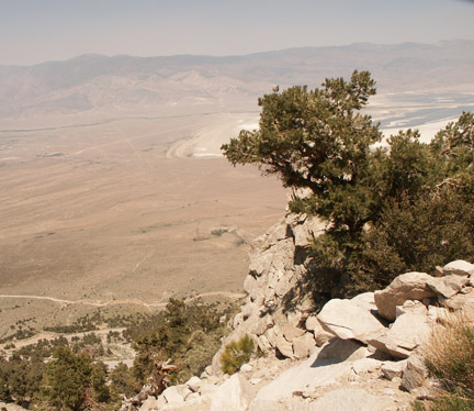
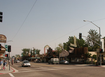
Lone Pine: Brothers
Bart McGee and Alney first settled the area in 1861 and aptly named the
location Lone Pine after a lone Jeffrey Pine tree at the base of Lone Pine
Canyon. Within a few years, the discovery of silver
and the opening of the Cerro Gordo mines expanded commerce both in Los Angeles and Lone
Pine. Farmers, ranchers, miners and
merchants created a hub of commerce and activity in this desert oasis. By the
1880’s the mining district went bust after shipping millions of silver, lead
and zinc to the city of Los Angeles. The mining industry, in turn, created a
steady corridor of freight wagons and supply centers to Los Angeles.
With a growing business climate and ever increasing population, the Los Angeles city planners knew they needed more water and
the Owens River would be the conduit of
life. In 1904 Los
Angeles began using the water supply of Owens
River and set out to buy water rights from Lone Pine to Lee Vining,
which is often referred to as the Water Wars.
By the 1920’s the
aqueduct was under construction and agriculture faced a steady decline. What was once a great productive area for
hay, fruits and vegetables became a producer of water for southern California. During this period of agricultural decline, Hollywood discovered the
wonderful landscapes surrounding Lone Pine in the Alabama Hills. To date over 250 films have utilized the
fantastic rock formations in the area.
Western film stars from Tom Mix, Roy Rodgers, Gene Autry, Hopalong
Cassidy and the Duke all filmed here in the Alabama Hills. (See Lone Pine Film Festival). Today Lone Pine is still a hub, and
recreation and the outdoors draw visitors from around the country.
Owens Lake: When the city of Los Angels
diverted water from Owens
Lake to an aqueduct in
1913, it could not anticipate the ecological calamities and financial responsibilities
it would face ninety-five years later.
With just a little more than a decade of shutting off the Owens River,
this once broad desert lake of nearly 100 square miles dried up to become an
alkali menace to nearby residents, who themselves have benefited from cheap
water drained from the Sierra Nevada Mountains.
During the 1870’s, steam barges plied the lake carrying ore from the
Cerro Gordo Mines. Waiting for them on
the other side, were long-lined freighters pulled by thirty to forty
mules. On any given day fifty or more
freighters would line up waiting for the precious cargo to be hauled to Los Angeles. Today nearby residents face some of the worst
coarse-particle air pollution in the United States from alkali dust
storms. Litigation continues on the Water War dispute and the management of the
Owens Lake Dust Mitigation Project.
Mt. Whitney: Hey, all you anglers out there! When was the last time you heard about three
fishermen scaling a 14,495 foot un-named mountain in one day when others had
failed? Three local fishermen, John
Lucas, Charles Begole and Albert Johnson, from the Lone Pine area worked their
way up to what is now the peak
of Mount Whitney and left
a note in a tin can to prove their feat.
Clarence King, a member of the California State Geological Survey had
erroneously climbed a companion peak of Mt. Whitney
and publicized his achievement in many professional journals. He named the mountain for his director. When government officials set off to
substantiate his climb in the history books, they were dismayed to find that
Mr. King had inadvertently climbed Mt.
Langley, which lies southeast of Mt. Whitney. Although the three fishing amigos named their
mountain, Fishermen’s Peak, the government bureaucracy had its way and Mt. Whitney
remained in perpetuity honoring a government director rather than honoring
piscatorial mountain climbers.
Companion Web Sites:
Glacier to Yellowstone (A complete guide to camping and fishing in Montana from Glacier to Yellowstone)
Fishing Tips 101 (Offering a "Mastering the Basics" series for freshwater fishing)
Bass and Trout Fishing Digest (Dave's hodge-podge of fishing adventures in Northern California and Oregon)

Leave a comment