Sherwin Lakes (day hike) / Mammoth Area

| No Comments | No TrackBacks

Lake Name: Sherwin Lakes  (five small lakes each less than five acres with the smallest (mid-center) being barren.    Elevation: 8,600

Road condition:   Paved to dirt

Day hike fishing: The hike is a little over two miles on a well-maintained trail

Region: Mammoth Lakes Ranger District (760) 924-5500

Lake size: The largest two lakes at approximately 5 acres are the last in the chain. Species: Rainbows and Brookies

Closest town or supplies: Mammoth Lakes

Contacts: Mammoth Lakes Visitor Bureau (888) 466-2666 / (760)-924-5500; Rick’s Sports Center (760) 934-3416; The Trout Fitter fly shop (760) 934-2517.

Nearest campground: Sherwin Creek Campground

Fishing season: General   

Tips: Wading is difficult due to the terrain and steep drop-offs. 

Favorite lures or bait: (See Category: Fishing Tips – Best Lures and Bait)

Favorite fly patterns: (See Category: Fishing Tips – Best Fly Patterns and Techniques)

Stocking information: Back country stocking program

Additional information / Sherwin Creek: Sherwin Creek is a small creek that is planted with 5,000 + Rainbows in and around the campground

Nearby fishing: Mammoth Lakes

Directions: From Highway 395 turn west at the junction with Highway 203.  One of the first exit roads from Highway 203 will be the Sherwin Creek Road, which is a dirt road.  Drive approximately three miles to the Sherwin Lakes Trailhead.

Mam-Sher-Laurel.jpg

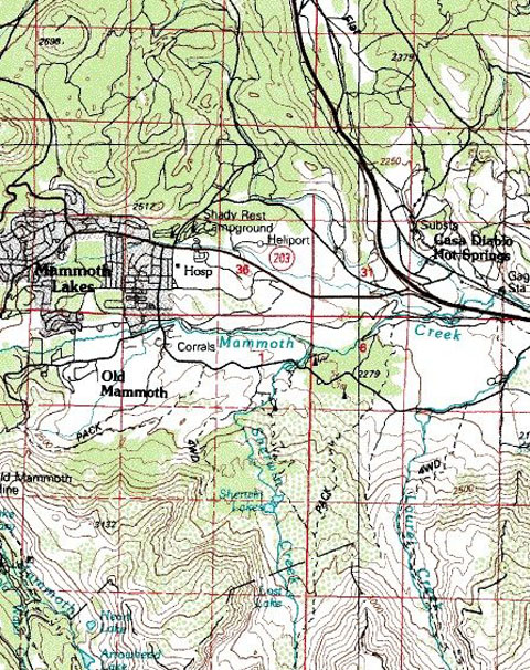
Map courtesy of mytopo.com.

No TrackBacks

TrackBack URL: http://www.guidetohighway395.com/cgi-bin/mt/mt-t.cgi/28

Leave a comment

Categories

Pages

OpenID accepted here Learn more about OpenID
Powered by Movable Type 5.04

About this Entry

This page contains a single entry by David Archer published on January 20, 2008 8:31 PM.

Hot Creek / Mammoth Lakes Area was the previous entry in this blog.

Mammoth Creek / Mammoth Lakes Area is the next entry in this blog.

Find recent content on the main index or look in the archives to find all content.