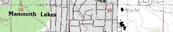
Highway 395, 17.6 miles north of Tom’s Place and 20.9 miles south of June Lake
Photo Gallery
Services and Accommodations
Restaurants and Eateries:
Public Internet Use Facilities: Access Business & Shipping Center (706) 934-4667; Kava Coffeehouse (760) 872-1010; Looney Bean (760) 934-1345; Mammoth Lakes Library (760) 934-4777; Wild Willy’s Mammoth Arcade (760) 924-1082
Museums and Point of Interest: Devil’s Postpile National Monument (619) 934-2289; Mammoth Museum (760) 934-6918; Mammoth Ski Museum (760) 934-6592
Events and Festivities: April 26: Opening Day for
the General Trout Season); August 11: Sierra Drifters/Crowley Lake
Stillwater Classic fishing derby (760-935-4301) November 15: General
Trout Season Closes
Summer Recreation: Biking, Birding, Camping, Fishing, Golfing, Hang Gliding, Hiking, Horseback Riding, Mountaineering, Photography, Rock Climbing
Winter Recreation: Skiing
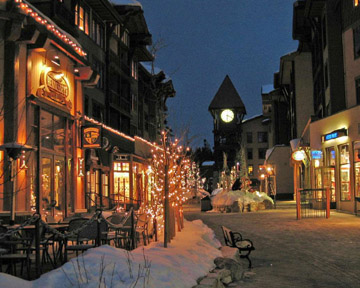
Photo courtesy of Mammoth Mountain
Sporting Goods Stores:
Nearby Fishing: Home: Mammoth Lakes: Fishing Fishing Tips (Convict Creek, Convict Lake, Crowley Lake, Crystal Lake, Hot Creek, Lake George, Lake Mary, Laurel Lakes, Mamie Lake, Mammoth Creek, McGee Creek Campground, McLeod Lake, Middle Fork of the San Joaquin River, Minaret Falls Campground, New Shady Rest Campground, Starkweather and Sotcher Lake, Sherwin Creek Campground, Red's Meadow Campground, Twin Lakes Campground, Upper Soda Springs Campground)
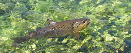
Photo by H. Blackburn. Courtesy of Mammoth Mountain
Nearby Camping: Home: Mammoth Lakes: Mammoth Area Camping (Agnew Meadows Campground, Agnew Meadows Horse Camp, Cold Water Campground, Convict Lake Campground, Crowley Lake Campground, Devils Postpile Campground, Lake George Campground, Lake Mary Campground, Pine City Campground, Pumice Flat Campground,
Chamber of Commerce and Visitor Links: Mammoth Lakes Visitor Center and Ranger Station, Main Street on Highway 203, (760) 924-5500, Open daily 9 am to 5pm. www.fs.fed/r5/inyo/vc/mammoth.html) // Mammoth Lakes Visitor Bureau // Mammothweb.
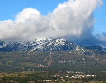
Photo courtesy of Mammoth Mountain
Community Parks:
Tours and Side-Trips: Crowley Lake, Devils Postpile National Monument (Red's Meadow and Rainbow Falls), Hot Creek Geological Site, Hot Creek State Fish Hatchery, Mammoth Lakes, Mammoth-Mono Geological Tour, Mammoth Mines, Minaret Vista, Obsidian Dome, Whitmore Hot Springs
RV Related:
Recreational Contacts:
Agnew Meadows Pack Train (760) 934-2345
Mammoth Lakes Pack Outfit 888-475-8747
McGee Creek Pack Station offers spot pack trips, dunnage trips, all inclusive trips and day rides. (760) 935-4324 (summer); (760) 878-2207 (winter).
Red’ Meadow Pack Station offers spot pack trips, dunnage trips, all inclusive trips and day rides. (760) 934-3445
Government Contacts:
Bureau of Land Management (Bishop Office) 787 Main Street, Suite P, Bishop, CA 93514
Department of Fish and Game: Season dates, licenses, restrictions, fish stocking
Inyo National Forest: books, maps and wilderness passes and permits: Mt. Whitney Ranger Station (760) 873-2500; White Mountain Ranger Station (760) 873-2500; Mammoth Ranger Station (760) 924-5500 www.fs.fed.us/r5/inyo
Devils Postpile
National Monument; Red’s Meadow and Rainbow Falls
I have combined these
“must see” side trips because the entrance road has driving restrictions. (See driving restrictions below)
The area of the Middle Fork of the
Road Restriction:
Mandatory travel restrictions are enforced for the Middle
Fork of the
The shuttle service to Reds Meadow/Devils Postpile began in 1979. The
shuttle was determined necessary to reduce the impact on the environment from
vehicle traffic. The narrow road into the Reds Meadow area serves as the only
access to the
Excessive vehicle use is the reason for a mandatory shuttle bus. However, some exceptions are recognized. Following is a list of most exceptions:
- Vehicles entering the valley before 7:00 am , or after 7:30 pm
- Vehicles carrying passengers with a disabled placard (once in the valley visitors must hike to most sites)
- Vehicles towing horse trailers or other livestock
- Campers camping in the Reds Meadow area
- Overnight Resort Guests
- Administrative vehicles
- Vehicles carrying car top boats, canoes, kayaks for use in valley
Exceptions are still charged the per person transportation fee.”
http://www.fs.fed.us/r5/inyo/recreation/redsmeadow.shtml
Hot Creek Geologic
Site
In the annals of trout fishing lore, Hot Creek is known far
and wide. Downstream from the Hot Creek
State Fish Hatchery, visitors leave their fly rods behind and witness hot gas
vents, boiling water, sky-blue
Hot Creek State Fish Hatchery raises a couple of million trout annually to be stocked locally. Considered to be one of the largest hatcheries in the state, the Hot Creek Hatchery also produces over 20 million trout eggs for hatcheries throughout the state.
Inyo Craters
The Inyo Craters are older than the Mono Craters. Looking like a funnel depression stuck in a
mountain, the Inyo Craters are
examples of super-heated steam explosions when ground water comes in contact
with rising magma. Referred to as
phreatic eruptions, the magma never reaches the surface. Radio carbon dating of wood debris sets the
time of activity at over 600 years ago.
The two Inyo craters pits are 600 feet in diameter and hold water at the
bottom of the funnel. The craters may be
reached by trail through a Jeffrey pine forest which ends at a picnic site. To reach the trail from
Mammoth-Mono
Geological Tour (The Mammoth Ranger District Headquarters offers a pamphlet
entitled, “Craters – Cones- Coulees” for a self-guided tour of 10 geological
sites.) You are mistaken if you believe
that visiting the area’s caldera, an area approximately 10 by 20 miles, will be
a stroll down memory lane when the last eruption occurred 100,000 years
ago. The Mono-Long Valley Caldera is
alive and well. So, what are the odds of
an eruption during your planned visit.
Scientists on staff at the U.S Geological Survey predict that the
probability of any activity is about 1%.
In other words, stick around for another 100,000 years for the
fireworks. The most recent eruptions
created the hills surrounding
The study of geology is not the study of ancient history. It is the study of Mother Earth in her slow, meticulous transformation of our planet. Should an unthinkable and unpredictable, less than catastrophic, eruption take place during your visit and in close proximity to where you stand, take heart from the fact that lava flows “rarely move faster than a brisk walk.” It will be the pyroclastic blast of hot ash venting at speeds “greater than 100 miles an hour” that will get you! I exaggerate, of course. Scientists predict that the next eruption will more than likely be small, and it could be limited to that of an explosive steam kettle, with the molten magma activity safely under the ground as it vaporizes underground water in its struggle to reach the surface. When sub-surface gas is pushed up just beneath the earth’s crust, and it is touched off by a finger-like vein of molten rock, “stuff” happens. It is precisely this rising finger of hot molten rock that keeps the USGS busy monitoring the area. In 1980-1982 scientists noticed a slight uplift of the ground surface in the Long Valley Caldera, as the magma and a finger-like projection pushed upwards along the south wall of the caldera.
The self-guided tour of the geological wonders around the
Mammoth area, including a trip to the Hot Creek Geological Site, is an
important part in understanding the region.
For informative articles on “Long Valley Caldera and Mono-Inyo Craters,”
and “Future Eruptions in
Mammoth Mines
Mammoth Mountain Ski Area: Encompassing 3,500 acres, 150 trails, 29 ski lifts and three full service slope-side lodges, Mammoth Mountain is the quintessential ski resort in the eastern Sierra Mountains.
Minaret
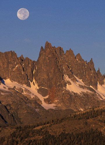
Photo courtesy of Mammoth Mountain
Located a short distance west of the Mammoth Mountain Ski Resort on Minaret Road, the Minaret Vista at the top of the pass affords an impressive view of the headwaters of the Middle Fork of the San Joaquin River, the Ritter Mountain Range and the jagged Minarets across the valley floor. A self-guided tour provides signed information on the geology and plant life in the area from the picnic area and Deadman Pass Trailhead.
Obsidian Dome
Obsidian, prized by the Indians for making spearheads and arrowheads, is a black, glass-like creation from lava that cooled rapidly after a surface eruption. Thousands of years after the caldera was formed, domes were created from magma pressure far below. The resulting ground swell forms a resurgent dome. Think of the Obsidian Dome as a magma after-thought or burp. If you have visited Mammoth Hot Springs Geothermal area, you can imagine what that burp smelled like!
Whitmore
Operated by
Companion Web Sites:
Glacier to Yellowstone (A complete guide to camping and fishing in Montana from Glacier to Yellowstone)
Fishing Tips 101 (Offering a "Mastering the Basics" series for freshwater fishing)
Bass and Trout Fishing Digest (Dave's hodge-podge of fishing adventures in Northern California and Oregon)

Leave a comment