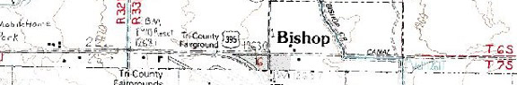
Highway 395, 15.6 miles north of Big Pine and 20.5 miles south of Tom’s Place
Restaurants and Eateries: (My favorites) Bar-B-Q Bills (760) 872-5535; Erick Schat’s Bakkery (760) 873-7156; La Casita (760) 872-2326
Public Internet Use Facilities:
Museums and Point of Interest: Laws Railroad Museum
(760) 647-6445; Paiute Shoshone Indian Cultural Center
Events and Festivities/ March 15: Blake Jones Trout
Derby – Bishop Chamber of Commerce; April 26: Opening Day for the
General Trout Season; May 23-26: Memorial Day Arts and Craft Show; August
28-September 1: Eastern Sierra Tri-County Fair; September 27-28: California
Wild Horse and Burro Show); November 15: General Trout Season Closes.
Summer Recreation: Biking, Birding, Camping, Fishing, Golfing, Hiking, Horseback Riding, Mountaineering, Photography, Rock Climbing
Winter Recreation: (See Mammoth Lakes)
Sporting Goods Stores: Barrett’s Outfitters (760) 872-3830Culver’s Sporting Goods (760) 872-8361; Mac’s Sporting Goods (760) 872-9201; Wilson’s Eastside Sports (760) 873-7520
Fly Shops: Brooks Flyfishing Specialists (760)
872-3581; Owen's River Fly Shop (760) 872-3830 - www.owensriverflyshop.com
Nearby Fishing: Home: Bishop: Fishing Fishing Tips (Bishop Creek, Heart Lake, Intake II, Mack Lake, McGee Creek, North Lake, Owens River, Pine Creek, Pleasant Valley Reservoir, Rock Creek, Rock Creek Lake, Ruby Lake, Sabrina Lake, South Lake
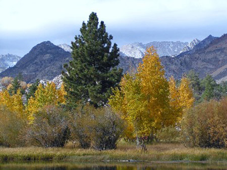
Photo courtesy of Bishop Chamber of Commerce
Nearby Camping: Home: Bishop: Camping (Big Trees Campground, Bishop Park Campground, Bitterbrush Campground, Forks Campground, Four Jeffrey Campground, Horton Creek Campground, Intake II Campground, Pleasant Valley Campground, PV Pit Campground, Mountain Glen Campground, North Lake Campground, Sabrina Lake Campground, Willow Creek Campground)
Bishop Chamber of Commerce
690 N. Main St., Bishop, California 93514; 760-873-8405; 888-395-3952
Toll free
Visitor center hours: 10AM to 5PM M-F 10AM to 4PM Weekends
Community Parks:
Tours and Side-Trips: Bishop Creek Canyon, Buttermilk Country, Fish Slough, Volcanic Tableland
RV Related:
Recreational Contacts: Bishop Country Club golf
course (760) 873-5828; Bishop Pack Outfitters (760) 873-4785; Paiute Palace
Casino; Keough’s Hot Springs (760) 872-4670; Pine Creek Pack Station (760)
387-2797; Rainbow Pack Outfitters (760) 872-8803. Rainbow Pack Outfitters offers overnight pack trips into the John Muir Wilderness and into King's Canyon Wilderness. They also offer guided day rides and fishing trips in the Bishop Basin.
Government Contacts:
Bureau of Land Management (Bishop Office) 787 Main Street, Suite P, Bishop, CA 93514
Department of Fish and Game: 407 W. Line Street, Bishop, CA 93514 (619) 872-1171 Season dates, licenses, restrictions, fish stocking etc.
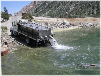
Photo courtesy of Bishop Chamber of Commerce
Inyo National Forest: books, maps and wilderness passes and permits: Mt. Whitney Ranger Station (760) 873-2500; White Mountain Ranger Station (760) 873-2500; Mammoth Ranger Station (760) 924-5500 www.fs.fed.us/r5/inyo
Bishop Expansion
Notes in Alphabetical Order
The
Across the broad Owens Valley lays a parallel mountain range
that stretches east of Lone Pine northwards into
Unassuming in height, the Bristlecone Pine grows on barren, windswept slopes with little surrounding vegetation, which protects them from wildfire danger. Stout and gnarly, their twisted limbs entwine as they stand proud survivors and testimony to the rigors of nature and time not in decades or centuries but in millennium. Slow to grow, their dense wood core wards off insects and disease. Dr. Edmund Schulman, who discovered the trees in the 1950’s, has studied the ring growth in living and dead trees and provided a 9,000 year record of weather patterns for the region.
The Ancient Bristlecone Pine Forest is 36 miles from Big
Pine. The last thirteen miles are
unpaved and rough in places. A picnic
site is located at approximately 16 miles.
The only campground is Grandview Campground, a few miles north of the
To visit Ancient Bristlecone Pine Forest, turn east on Highway 168 from Highway 395 in Big Pine. After thirteen miles, turn left onto Road 01, a signed road to the forest.
Bishop
With the discovery of gold in
By 1863 a stage coach line was established from Bishop to
Continuing silver and gold strikes brought in the Carson
& Colorado Railroad that connected
With little private land to expand, Bishop nonetheless
became prosperous as the tourism hub of
Blake Jones Fishing Derby
The next derby will be held Saturday, March 15, 2008. The Blake Jones Trout Derby is held every March....The site of the derby is along the Owens River, just below the Pleasant Valley Reservoir, six miles north of Bishop. Put on by the Bishop Area Chamber of Commerce & Visitors Bureau, this pre-season event is a great chance to wet your line and hone your fishing skills while getting a chance to win big prizes!
Fishing during the derby is allowed in the reservoir and along the river only as all others waters are closed until the last Saturday in April. Tons of trout are planted just before the derby by both Alpers Trout Hatchery and the DFG. and you can enter your catch in any number of categories including "Blind Bogey" and "Big Fish" for a chance to win your part of over $10,000 in prizes including high quality rod & reel combos, float tubes, custom lures, lodging, dinners and other goodies from local merchants and friends of the Bishop Chamber.... During the derby, you are allowed to fish in both the Pleasant Valley Reservoir and any section of the lower Owens River (except the catch & release Wild Trout area) and bring your catch to the derby headquarters at the reservoir to have them weighed by Hal and the crew.
Each participant receives five "fish cards" so that one can enter up to five fish (the legal limit) in the contest to increase the chance of winning. Everyone's fish cards are put into the hopper and those that match the Blind Bogey weight will win prizes. There are also prizes for "Biggest Trout" plus lots more!
The Blind Bogey fish this year weighed 11oz. (caught by a secret fisherman two days before the derby) and 20 lucky fishermen who caught fish that matched that size had their fish cards drawn with first prize a fisherman's dream package contributed by local sporting goods dealers Barrett's Outfitters, Mac's Sporting Goods and Culver's Sporting Goods along with the Paiute Palace, Sears, Berkley and Cabelas.
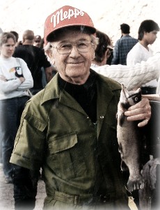
Who was Blake Jones?
Whenever you bait your hook with Powerbait or any of the other modern cheese baits, you can thank the late Blake Jones. Jones invented cheese bait which was unique when it was introduced back in the 1950s. Before Blake Jones came along anglers had to use Velveeta cheese spread or cut small pieces from a block of cheese which easily fell off the hook when immersed in water. Blake's special cheese bait stayed on the hook even during heavy casting. But Blake Jones was probably best known as one of the legendary anglers in Bishop. Along with his wife, Peggy, he fished all over the high country and taught hundreds of people how to fish thelakes and streams of the High Sierra. Longtime local resident and business owner Don Barrett explained. 'They were the type of people who would never hesitate and help people fish. They might hand someone a jar of bait and show them how to use it. They were just that way.'"
For complete details on the derby go to www.bishopvisitor.com
Photo courtesy of Bishop Chamber of Commerce.
Buttermilk Country
Named by a local dairyman back in the 1870’s, the area is
quite popular with family rock climbers and “bouldering” experts alike, who use
only their fingers and toes to climb.
The area is beautiful in the spring both for wildflowers, birds and a
large deer herd that winter in the area.
To reach Buttermilk Country, turn west on
Fish
Bishop or connect with the
Keough’s Hot Springs.
With a claim to be the Eastern Sierra’s largest natural
Companion Web Sites:
Glacier to Yellowstone (A complete guide to camping and fishing in Montana from Glacier to Yellowstone)
Fishing Tips 101 (Offering a "Mastering the Basics" series for freshwater fishing)
Bass and Trout Fishing Digest (Dave's hodge-podge of fishing adventures in Northern California and Oregon)

Leave a comment